Permafrost thaw and Coastal Dynamics
Vladimir Romanovsky
Dmitry Nicolsky
Louise Farquharson
University of Alaska Fairbanks, Geophysical Institute, Permafrost Lab
Task overview
The Permafrost Degradation and Coastal Dynamics Task aims to develop a modeling package to evaluate and predict the rate, extent, and mechanisms of permafrost degradation in the next century for the North Slope Borough, specifically for Utqiagvik, Wainwright, Point Lay, and Kaktovik.
Outcomes will be used in other components of the project (i.e. Task #X and #Y) to evaluate and predict the effects of permafrost degradation and associated land loss on civil infrastructure systems and Arctic communities.
Overarching goal
The overarching goal of this task is to model and predict the rate, magnitude, and mechanisms of permafrost degradation and associated land loss within Alaska’s North Slope Borough communities
- Part a: Model ground thermal regime, permafrost degradation and potential ground subsidence within the villages between now and the end of the century.
- Part b: Identify primary driving factors behind the coastal erosion and project potential land loss at the coastal villages.
What do we plan to do?
Observe changes in permafrost and the coastline
In coordination with the community, we will use a combination of in-situ ground temperature measurements, drone surveys, and remote sensing to observe permafrost thaw and coastal dynamics within each community. The community input is essential to identify the best locations for each of these observations both within the villages themselves and in the surrounding area. We also plan to collect local traditional knowledge and pre-existing data on environmental forcing factors that may influence changes in both the ground thermal regime and rates of coastal change.
Model future permafrost thaw and coastal erosion
We will project future change using two modeling approaches. Firstly, we will model future permafrost thaw using a model that uses a combination of in-situ ground temperature measurements, landscape and infrastructure maps, and climate data (air temperature and snow depth projections available through Scenarios Network for Alaska and Network Planning, https://www.snap.uaf.edu/). Output from this model will be used to create permafrost thaw projection maps for the North Slope Region with a particular focus on the communities of Utqiagvik, Wainwright, Point Lay and Kaktovik. Results from the GIPL model will feed into a machine learning based probabilistic model that will help better constrain the forcing factors responsible for coastal erosion. We will combine our observations of permafrost ground temperature and coastal erosion with newly available observational data such as sea ice cover, wave dynamics, storm frequency and magnitude, and ocean temperature and use this to train a ML algorithm – maximum entropy (MaxEnt) principle model . The MaxEnt and jackknife tests are to identify a driving set of variables for land loss within each geomorphological system and could be used to estimate the future rate of erosion at the study sites. The performance of the coastal erosion module will be evaluated using coastal erosion rates, which will be estimated from remote sensing based digital mapping efforts. Once the MaxEnt model is parameterized and a set of driving parameters is established, we will forecast future rate and extent of erosion and thermokarst using available climate scenarios (e.g. environmental data from the permafrost model outputs, predicted sea ice projections, storm activity). Output from the erosion module will be used to inform the temperature dynamics module about the land loss and proximity of the ocean to the modeling grid cell.
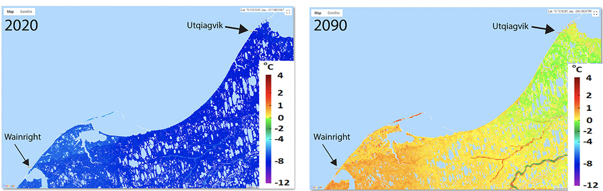
Figure 1. Example of preliminary permafrost model output for the NE Chukchi coastline and communities of Utqiagvik and Wainwright. The panel on the left shows ground temperature in 2020 while the panel on the right shows projected ground temperature under the United Nations Intergovernmental Panel on Climate Change (IPCC) RCP 8.5 greenhouse gas emission scenario by the end of the century.